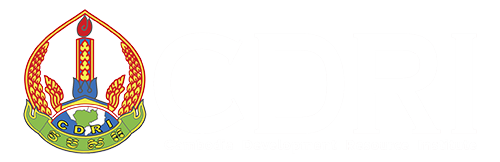
An Investigation of Land Cover and Land Use Change in Stung Chrey Bak Catchment, Cambodia
Keyword: Land use and land cover change, remote sensing and GIS, Stung Chrey Bak catchment, forest degradation, irrigation and agricultural expansion
Abstract/Summary
This study investigates land use and land cover (LULC)
change in the Stung Chrey Bak catchment, Kompong Chhnang province, Cambodia,
over the period 1989–2008. Using a mixed-methods approach that combines
satellite remote sensing (Landsat and ASTER imagery) with field interviews and
participatory mapping, the research identifies significant transformations in
forest cover, rice field expansion, and land tenure dynamics. The findings
reveal a decline in evergreen and secondary forests, largely due to logging,
agricultural expansion, and land speculation. The Khmer Rouge era (1975–1979)
played a pivotal role in shaping current land use patterns through forced
deforestation and irrigation development. Post-conflict periods saw further
degradation due to illegal logging and weak governance. While rice field
expansion has contributed to land conversion, its impact is relatively minor
compared to commercial agriculture and economic land concessions. The study
highlights the limitations of relying solely on remote sensing and emphasises
the value of integrating qualitative data to capture local nuances. It
concludes that sustainable land and water resource management in the catchment
requires improved governance, integrated planning, and recognition of local
land use practices.
Related Publications
Contract Farming in Cambodia: Good Practices and Lessons Learned
01-Jan-2021